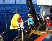
Coastal Carolina scientists work on wind energy studies
The CMSS faculty, staff and students deployed the instrument system to feed near real-time measurements that will support wind energy studies for validation of CCU's interactively coupled ocean/wave/atmospheric modeling system. The instrument system will also feed into the National Weather Service's weather modeling system.
The reef where the CCU buoy was deployed is named after Ron McManus, a longtime community leader in North Myrtle Beach and driving force behind the initiation of the artificial reef system of North Myrtle Beach. The Jim Caudle Artificial Reef Foundation Endowment helps support student research through CCU's Center for Marine and Wetland Studies (CMWS). Data from the recently deployed buoy should start posting on the school's website in a few days.
CCU, the University of South Carolina and the South Carolina Institute of Archaeology and Anthropology received $1.5 million in federal and state grant money to use the school's geophysical mapping system to characterize areas wind developers should embrace or avoid off the coast.
Paul Gayes, director of the school and the lead technical investigator, said the project will use continuous geophysical mapping of certain portions of the ocean floor to help determine what wildlife habitats and cultural resources are just off the coast.
The Coastal Explorer, CCU's 54-foot aluminum research vessel, is assisting in deployment of the buoys and to transfer extra staff to help with the complex operation.
The buoy at Ron McManus Reef and a second instrument system installed off Frying Pan Shoals Light Tower, 25 miles offshore of Cape Fear, was deployed from the National Oceanic and Atmospheric Administration (NOAA) ship Nancy Foster during a cooperative fishery habitat survey conducted by NOAA and CCU scientists. The cruise is supporting two CMWS master's degree projects and aiding in the improvement of mapping of critical habitat in the region.


