HUGO team forecast is right on track
by Bell
For the past 10 years, Shaowu Bao has spent most of his working life studying hurricanes, but he never experienced one up close until Hurricane Matthew visited the South Carolina coast in October.
When Bao and his fellow scientists on CCU’s Hurricane Genesis & Outlook (HUGO) team predicted back in June that the 2016 Atlantic hurricane season would produce one hurricane that would make landfall on the Gulf Coast and one on the U.S. East Coast, he had no idea that one of them would wind up in his own backyard.
But when he looked out of his kitchen window on Oct. 8 and watched the wind uproot a tree, the meaning and importance of his career were driven home to him as never before.
“I have always been aware that our work is useful and that it helps the community,” said Bao, “but in this case, the community was mine. It definitely makes it all more real.”
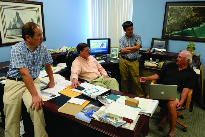
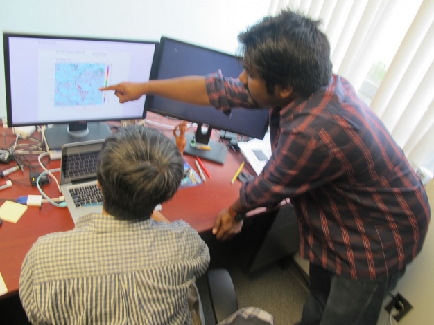
Bao, a computational, deterministic numerical modeler specializing in meteorology and oceanography, is a key member of the distinguished team of scholars assembled by veteran climatology scientist Len Petrafesa and Paul Gayes, longtime director of CCU’s Burroughs & Chapin Center for Marine and Wetland Studies. The other members are Tingzhuang Yan, a meteorological oceanographer with a background in statistical modeling of climate and weather systems; and Mansur Ali Jisan, a CCU student earning a master’s degree in coastal marine and wetland studies.
This group of scientists breathed a collective sigh of relief when the 2016 Atlantic hurricane season came to an official end last week on Nov. 30. But even though they had to deal with some downed trees, damaged roofs and missing shingles from Matthew, they all feel a sense of triumph in having produced a forecast product that was right on the money — more accurate, in fact, than those of many other respected organizations and institutions.
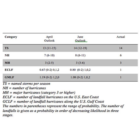
The first outlook forecast for the 2016 season produced by CCU’s HUGO Project back in April predicted a “near to above normal” season. The team updated its outlook in late June with calculations that proved to be correct in nearly every major category, as the graph below indicates.
“The HUGO Hurricane Landfall Outlook forecast aced the 2016 season,” said Pietrafesa, senior research professor in CCU’s School of the Coastal Environment and a former chair of the National Oceanic & Atmospheric Administration (NOAA) Advisory Board. “CCU was the only forecast organization to correctly predict one landfall in the Gulf of Mexico and one landfall on the Eastern Atlantic seaboard, and the other forecast predictors were highly accurate.”
Hurricane Hermine made landfall as a Category 1 hurricane on the Florida Panhandle’s Gulf Coast on Sept. 2, 2016. Hurricane Matthew made landfall on the U.S. East Coast as a Category 1 hurricane near McClellanville, S.C., on Oct. 8.
Matthew was one of the most destructive storms in the history of Atlantic hurricanes, reaching Category 5 as it tracked across the Caribbean Sea. The hurricane made its first landfall in Haiti as a Category 4 on Oct. 4, also hitting Cuba later that day. Still a Category 4 hurricane, Matthew made a third landfall on Grand Bahama Island on Oct.6 before tracking parallel to the Florida, Georgia and South Carolina coast. Its fourth and final landfall was on the Cape Romaine National Wildlife Refuge near McClellanville, 55 miles south of Myrtle Beach.
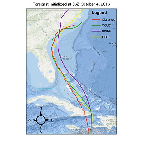
In addition to forecasting the seasonal outlook, the HUGO team calculates specific data on the probable pathway, wind, precipitation and storm surge of approaching storms in real time. The team’s forecasts were more consistently accurate in these categories than those of many other leading climatological organizations on both Hermine and Matthew, according to Pietrafesa. The model forecast, shown in the illustration below, of Hurricane Matthew’s path as of Oct. 4 shows that the HUGO team’s predicted track in green (CCUC) closely overlays the official observed track of the actual storm in red (OFCL), in comparison to the NOAA Natural Hurricane Center Forecast (in purple) and the NOAA Geophysical Fluid Dynamics Lab at Princeton University (in yellow). CCU’s model outperformed 21 other institutional forecasts, according to Pietrafesa.
The HUGO team worked tirelessly before and during Matthew. Ali Jisan kept the CCU model system running every six hours from Oct. 3 through Oct. 10. Bao, Pietrafesa and Gayes were on multiple conference calls with S.C. State Guard Lt. Col. Marguirete McClam. CCU Outreach Specialist Deb Stirling helped advise the State Guard on the incoming wind and precipitation forecasts. CCU President David DeCenzo and computer science professor Mike Murphy were able to keep the CCU computational platform up and running until Matthew finally struck. It was an exhilarating but rewarding effort, as the team worked to assist the S.C. State Guard and Emergency Management.
Paul Gayes, who has led the Burroughs & Chapin Center for Marine and Wetland Studies since 1989, says that this remarkable achievement by the HUGO team fits into a broad framework of research the center is conducting.
“The center takes an integrative approach to the study of coastal enrivonments and processes, focusing on the interactions between the land, the ocean and the atmosphere,” said Gayes. “The HUGO team’s effort is one example of how we apply the best available science to projects that provide a direct service to the community.
“What is critically needed is better predictive capabilities for environmental change whether on the scale of an event, such as a hurricane, or over annual or longer-term periods. To do this, we focus on integrating technology to better sense environmental conditions across the coastal region, where there are such complex transitions going from land to sea, and integrating those measurements into the advanced models being developed here. The ultimate result is improving predictive capabilities needed to better manage our critical natural resources and associated economies.”
The HUGO team’s forecast for the 2015 Atlantic hurricane season was also highly accurate. The 2015 outlook correctly forecast a most likely scenario that no hurricanes would make landfall on either the East or Gulf coasts. Last year’s outlook also accurately forecast the number of hurricanes at four.
The HUGO Outlook program was established in 2013 in CCU’s Department of Coastal and Marine Systems Science. The outlook model is based on calculations of 22 climatological factors encompassing oceanic, atmospheric and shoreline activity. The model also considers detailed statistical data from previous Atlantic hurricanes going back to 1950, a methodology that has produced highly accurate track predictions in hind-casting tests conducted by the team at CCU. The HUGO team has made a significant advance in computing a key factor in advance of an upcoming season, the Accumulated Cyclone Energy (ACE) Index, which calculates the kinetic energy of storms based on the summation of all tropical storm wind values, observed over an entire hurricane season.
Also, because the HUGO model system provides specific data on probable storm surge and inundation as a hurricane approaches, including time, location and statistical representations of expected water depth along the coastline, it has special relevance for emergency management officials in their logistical planning in the event of evacuations.