HUGO team at CCU forecasts ‘slightly below normal’ hurricane season for 2017
Scenarios for the 2017 hurricane season are dependent on a number of factors, according to Len Pietrafesa, research professor in CCU's Burroughs & Chapin Center for Marine and Wetland Studies (BCCMWS) and leader of the HUGO team.
"A main climate factor, the El Nino Southern Oscillation (ENSO), is between cold (La Nina) and warm (El Nino) phases in the equatorial Pacific Ocean and has confused the issue to date as shown by a recent National Oceanic & Atmospheric Administration forecast of 'above normal' and a Colorado State University forecast of 'below normal,' " says Pietrafesa.
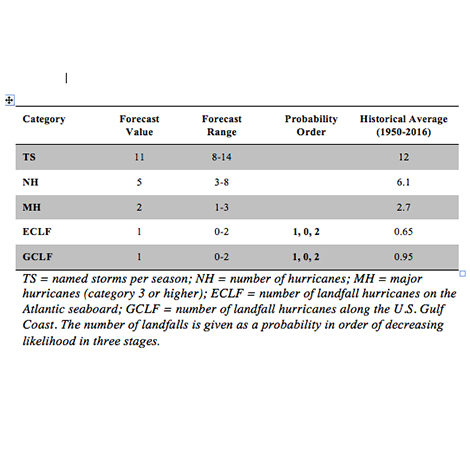
Based on climate factors available in early June, the HUGO outlook (detailed in the attached table) predicts that there will be a range of 8 to 14 named tropical storms (with 11 most likely and 12 being the long-term average), with from 3 to 8 (with 5 most likely and 6 being the long-term average) becoming hurricanes and 1 to 3 (with 2 most likely and 3 being the long-term average) becoming major hurricanes during the 2017 season (June 1 to Nov. 30).
For both the U.S. East Coast and the U.S. Gulf Coast, the HUGO study predicts a landfall probability range of zero to 2 for both coastlines. The most probable scenario calls for at least 1 hurricane landfall on the East Coast and at least 1 hurricane landfall on the Gulf Coast during the 2017 season. The second most likely scenario is that no hurricanes will make landfall on either coast. The third most likely possibility is that 2 hurricanes will make landfall on the U.S. Atlantic East Coast and for 2 hurricanes to make landfall on the U.S. Gulf Coast.
"The key issues at this point in time are (1) how the El Nino will be developing in the Equatorial Pacific Ocean and (2) how warm the upper ocean of the North Atlantic Ocean will become," says Pietrafesa. The above scenario is highly dependent on the variations of climate factors in June and July, primarily ENSO and the Atlantic Multi-decadal Oscillation (AMO), which is the ocean surface temperature of the North Atlantic Ocean. An updated outlook will be released in late July as more observational climate data become available.
Past HUGO outlook forecasts have proved to be highly accurate. The 2016 and 2015 outlooks were correct in nearly every category (number of tropical storms, number of major hurricanes, landfalls on both the East Coast and Gulf Coast). The 2015 outlook correctly forecast a most likely scenario that no hurricanes would make landfall on either the East or Gulf coasts and also accurately forecast the number of hurricanes at 4. The 2016 forecasts for all numbers were spot on, including 1 landfall on the Gulf Coast (Hermine) and 1 on the East Coast (Matthew).
The end-to-end HUGO model system was developed in 2013 by a group of climatological and weather scholars of international standing led by Pietrafesa, a computational fluid physicist and former chair of the NOAA science advisory board and of the National Hurricane Center external advisory panel. Other members of the CCU team are: Shaowu Bao, a computational, deterministic numerical modeler specializing in meteorology and oceanography and a professor in coastal and marine systems science at CCU; Tingzhuang Yan, a meteorological oceanographer with a background in statistical modeling of climate and weather systems and a Burroughs & Chapin Research Scholar at CCU; and Paul Gayes, CCU professor and BCCMWS director.
The HUGO hurricane seasonal outlook model is based on calculations of 22 climatological factors encompassing oceanic, atmospheric and shoreline activity. The model also considers detailed statistical data from previous Atlantic hurricanes going back to 1950, a methodology that has produced highly accurate track predictions in hind-casting tests conducted by the team at CCU. The HUGO team has made a significant advance in computing a key factor in advance of an upcoming season, the Accumulated Cyclone Energy (ACE) Index, which calculates the kinetic energy of storms based on the summation of all tropical storm wind values, observed over an entire hurricane season.
In addition to the seasonal outlook, the model system predicts the track, intensity, surge and the inundation and flooding potential of an incoming hurricane seven days out. The HUGO model system is updated daily until the hurricane makes landfall, providing specific data on probabilistic storm surge and inundation including time, location and statistical representations of expected water depth along the coastline.
The Hurricane Seasonal Outlook is a greatly advanced version of the model system originally developed in Yan's Ph.D. dissertation in 2006 at North Carolina State University and funded through a grant from the NOAA Coastal Services Center in Charleston, the National Research Council and the NOAA National Centers for Environmental Prediction. The individual hurricane track and intensification and landfall surge and flooding model system is based on the interactively coupled model system developed by Bao and Pietrafesa under prior NOAA funding through the NOAA Coastal Services Center in Charleston and by Bao during his tenure as a staff scientist at the National Center for Atmospheric Research in Boulder, Colo.
HUGO team tests new hydrology model for river/watershed flooding
The HUGO model system is testing a new hydrology feature that predicts river flow and flooding along the watersheds of South Carolina. The new feature has special relevance for emergency management officials in their logistical planning in the event of evacuations because it examines the timing and amount of lateral inundation emanating from rivers as they purge themselves of excess hurricane waters.
The HUGO team and Jason Hallstrom of Florida Atlantic University (FAU) are developing the hydrology component, with funding from the National Science Foundation, to assimilate flooding river velocity data into the model system track. This includes developing novel techniques to define flooding river velocity structure using FAU/CCU GPS micro-drifters, particle tracking from drones and surface sled mounted acoustic Doppler current profilers.
For more information about CCU's HUGO Project, contact Bao at 843-349-6633 or sbao@coastal.edu or Pietrafesa at 704-910-7047 or email lpietraf@coastal.edu.