Updated CCU outlook forecasts higher probability of hurricane activity for 2017 season
Based on climate factors available in late July and early August and projected climate signals in the upcoming months, the new report anticipates a "near to above normal" hurricane season for the remainder of 2017, a change from the "slightly below normal" season projected in June, according to Len Pietrafesa, research professor in CCU's Burroughs & Chapin Center for Marine and Wetland Studies (BCCMWS) and leader of the HUGO team.
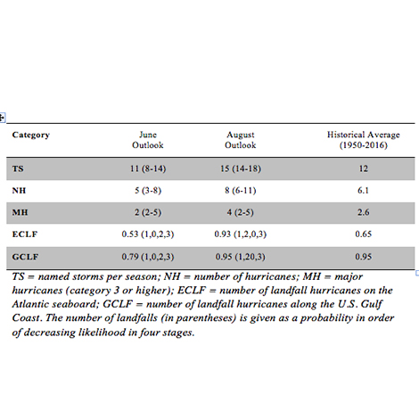
The latest HUGO outlook, calculated recently and detailed in the table above, predicts that there will be eight named hurricanes this season, rather than the five predicted previously. The new report also indicates the likelihood that there will be four major hurricanes (Category 3 or above) in 2017 rather than two, as was forecast in June.
In the latest outlook, the statistical probability of a landfall on the East Coast rose from 0.53 to 0.93, and on the Gulf Coast from 0.79 to 0.95, in comparison with the June report. The August outlook forecasts a most likely scenario that one hurricane will make landfall on both the U.S. East Coast and the U.S. Gulf Coast during the 2017 hurricane season (June 1 to Nov. 30), which is consistent with the previous report from June; however, the second most likely scenario is that two hurricanes will make landfall on both the U.S. East Coast or the Gulf Coast this season - a significant change from the last report, in which the second most likely scenario was that no hurricanes would make landfall on either coast.
The scenarios for the remainder of the season are highly dependent on the variations of climate factors in August, September and October, traditionally the most active period in the hurricane season.
"Compared with the June forecast, the August forecast indicators increased significantly in extent," said Pietrafesa. "The primary reasons for this increase are a reduced likelihood of a moderate El Niño warm phase and continued anomalous warming in the tropical Atlantic Ocean."
The end-to-end HUGO model system was developed in 2013 by a group of climatological and weather scholars of international standing led by Pietrafesa, a computational fluid physicist and former chair of the NOAA science advisory board and chair of the National Hurricane Center external advisory panel, and Shaowu Bao, a computational, deterministic numerical modeler specializing in meteorology and oceanography and a professor in coastal and marine systems science at CCU and a member of the National Center for Atmospheric Research operational university advisory team. Other members of the CCU team are Tingzhuang Yan, a meteorological oceanographer with a background in statistical modeling of climate and weather systems and a Burroughs & Chapin Research Scholar at CCU and who harvested the new climate data; and Paul Gayes, CCU professor and BCCMWS director, who evaluated the integrity of the empirical climatological data.
For more information about CCU's HUGO Project, contact Bao at 843-349-6633 or sbao@coastal.edu or Pietrafesa at 704-910-7047 or lpietraf@coastal.edu.