CCU hurricane forecast highly accurate for 2016 season
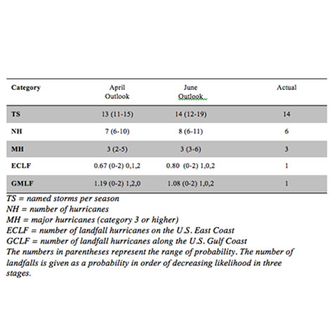
The first outlook forecast for the 2016 season produced by CCU's HUGO Project back in April predicted a "near to above normal" season, The team updated its outlook in late June with calculations that proved to be correct in nearly every major category, as the graph above indicates.
"The HUGO forecast aced the 2016 season," said Pietrafesa, senior research professor in CCU's School of the Coastal Environment and a former chair of the National Oceanic & Atmospheric Administration (NOAA) Advisory Board. "CCU was the only forecast organization to correctly predict one landfall on the Gulf of Mexico and one landfall on the U.S. East Coast, and the other forecast predictors were highly accurate."
Hurricane Hermine made landfall as a Category 1 hurricane on the Florida Panhandle's gulf coast on Sept. 2, 2016. Hurricane Matthew made landfall on the U.S. East Coast as a Category 1 hurricane near McClellanville, S.C., on Oct. 8.
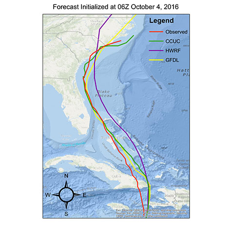
In addition to forecasting the seasonal outlook, the HUGO team calculates specific data on the probable pathway, wind, precipitation and storm surge of approaching storms in real time. The team's forecasts were more consistently accurate in these categories than those of many other leading climatological organizations on both Hermine and Matthew, according to Pietrafesa. The model forecast (pictued above) of Hurricane Matthew's path as of Oct. 4 shows that the HUGO team's predicted track in green (CCUC) closely overlays the official observed track of the actual storm in red (OFCL), in comparison to the NOAA Natural Hurricane Center Forecast (in purple) and the NOAA Geophysical Fluid Dynamics Lab at Princeton University (in yellow). CCU's model outperformed 21 other institutional forecasts, according to Pietrafesa.
The HUGO team's forecast for the 2015 Atlantic hurricane season was also highly accurate. The 2015 outlook correctly forecast a most likely scenario that no hurricanes would make landfall on either the East or Gulf coasts. Last year's outlook also accurately forecast the number of hurricanes at four.
The HUGO Outlook program was established in 2013 in CCU's Department of Coastal and Marine Systems Science. The end-to-end model system was developed by a group of climatological and weather scholars of international standing led by Pietrafesa. Other members of the CCU team are Shaowu Bao, a computational, deterministic numerical modeler specializing in meteorology and oceanography; Tingzhuang Yan, a meteorological oceanographer with a background in statistical modeling of climate and weather systems; Mansur Ali Jisan, a CCU student earning a master's degree in coastal marine and wetland studies; and Paul Gayes, longtime CCU professor and director of CCU's Burroughs & Chapin Center for Marine and Wetland Studies.
"The team's performance during Hurricane Matthew was an exhilarating but rewarding effort," said Pietrafesa. " Mansur Ali Jason kept the CCU model system running every six hours from Oct. 3 through Oct. 10. Shaowu Bao, Paul Gayes and I were on multiple conference calls with the S.C. State Guard on the incoming wind and precipitation forecasts. CCU President David DeCenzo and computer science professor Mike Murphy kept the CCU computational platform up and running until Matthew finally struck."
The HUGO hurricane seasonal outlook model is based on calculations of 22 climatological factors encompassing oceanic, atmospheric and shoreline activity. The model also considers detailed statistical data from previous Atlantic hurricanes going back to 1950, a methodology that has produced highly accurate track predictions in hind-casting tests conducted by the team at CCU. The HUGO team has made a significant advance in computing a key factor in advance of an upcoming season, the Accumulated Cyclone Energy (ACE) Index, which calculates the kinetic energy of storms based on the summation of all tropical storm wind values, observed over an entire hurricane season.
Also, because the HUGO model system provides specific data on probable storm surge and inundation as a hurricane approaches, including time, location and statistical representations of expected water depth along the coastline, it has special relevance for emergency management officials in their logistical planning in the event of evacuations.
For more information about CCU's HUGO Project, contact Pietrafesa at 843-349-4017 or 704-910-7047 or email lpietraf@coastal.edu.