Research Equipment
Boat Operations in the Gupta College of Science houses a sophisticated array of instrumentation, ensuring a comprehensive approach to marine exploration and research. Among the cutting-edge tools on board are geophysical surveying equipment, current profilers, water quality monitoring sensors, a remotely operated vehicle (ROV), and precision positioning systems. This impressive suite of instruments not only facilitates advanced research endeavors but also serves as valuable assets for engaging class demonstrations and activities. Students and researchers alike benefit from hands-on experiences with geophysical surveying, underwater exploration using the ROV, and precise positioning techniques. Additionally, the water quality monitoring sensors contribute to a deeper understanding of marine ecosystems, making boats a versatile platform for both scientific inquiry and educational initiatives. For any inquiries about the specifications or availability of the instrumentation, please feel free to reach out to Cobi Christiansen at cmchrist@coastal.edu.
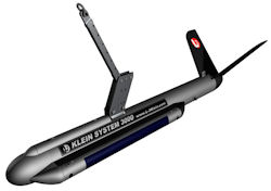 |
KLEIN 3000 DIGITAL SIDE SCAN SONAR
- Frequencies: 100/500 kHz
- Maximum Range: 600m (100kHz); 150m (500kHz)
- Depth Rating: 1500m
- Applications: Side imaging, Geological surveys, Geohazard surveys
|
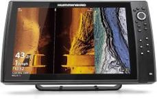 |
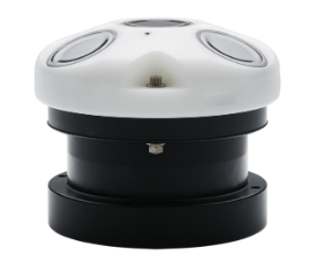
HELIX 10 CHIRP MEGA SI+ GPS G3N
- Frequencies: 20/83/200/455/800 kHz & 1.2 MHz
- Maximum Range: 365m
- Applications: Side/Down imaging; GPS mapping; Geological surveys, Geohazard surveys; Fishfinder
|
 |
EDGETECH SB-512i SUB-BOTTOM PROFILING SYSTEM
- Frequencies: 500 Hz-24 kHz
- Vertical Resolution: 8-19 cm (dependent on frequency)
- Depth Rating: 300m
- Applications: Sub-Bottom profiling, Geological surveys, Geohazard surveys, Buried object locations
|
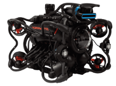 |
OCEANBOTICS SRV-8 UNDERWATER DRONE
- Dual mode camera that records in 1080HD
- Oculus multibeam imaging sonar (375 kHz-3 MHz)
- Navigation: Commercial grade AHRS/IMU
- 8 dynamic vectored thrusters for maneuverability and stabilization
- Swappable batteries (up to 8 hours of use)
- Depth Rating: 305m
- Sensors: Depth, Temperature, Heading, XO2s Sonde
- Applications: Coupled video, sonar, and water quality surveys
|
 |
TELEDYNE RDI ADCP W/ BOTTOM TRACKING
- Frequency: 1200 kHz
- Maximum Profiling Range: 20m
- Ping Rate: 2 Hz
- Beam Angle: 20°
- Depth Rating: 200m
- Sensors: Temperature, tilt, compass
- Applications: Precision current profiling
|
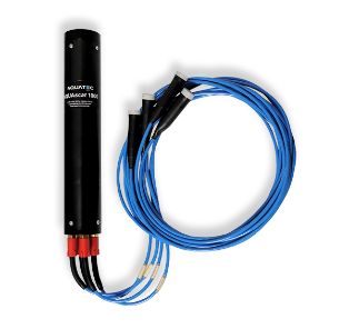 |
AQUAscat 1000R
- Frequencies: 300/500 kHz, 1/2/2.5/4/5 MHz (4 frequencies at a time)
- Maximum Profiling Range: 10m
- Transmission Rate: 128 Hz max pulse rate
- Depth Rating: 1000m
- Sensors: Temperature, pressure, optional turbidity
- Applications: Sediment research, Dredge plums, Turbulence
|
 |
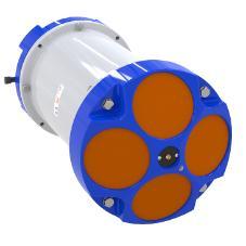
AWAC Current Profiler
- Frequency: 1 MHz
- Beams: 3 beams 120° apart, 1 vertical beam
- Maximum Profiling Range: 30m
- Internal Sampling Rate: 7 Hz
- Depth Rating: 35m
- Sensors: Temperature, compass, tilt, pressure
- Applications: Current profiles, Wave measurements
|
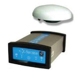 |
C-NAV 3050 GNSS RTK GPS SYSTEM
- Output Data Rate: <1 Hz to 100 Hz
- Accuracy: L1-RTK supports 1 cm accuracy up to a 5km baseline
- C-Nav Corrections Service: < 5 cm position accuracy
- NTRIP support for generation of differential GNSS corrections
- Outputs several standard NMEA-0183 data strings
- Applications: Dynamic positioning, Topographical surveys, Hydrographic surveys, Real-Time positioning
|